The oldest 3D map in Europe found in Brittany
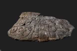
The recently rediscovered Bronze Age slab found in Brittany, France is being called the oldest 3D map of Europe. Researchers from Inrap, the University of Bournemouth, the CNRS and the University of Western Brittany (UBO) have shared findings of the oldest relief map in Europe, dating from the Early Bronze Age (2150-1600 BC). Their research focused on the engraved slab of Saint-Bélec (Leuhan, Finistère).
The approximately 2 m by 1.5 m slab, first discovered in 1900, was found in a cellar of a castle in Brittany, France in 2014. Archaeologists who have studied the patterns carved into the 4,000-year-old stone said they believed the markings were a map of an area in western Brittany. It was first discovered in 1900 during excavations on a prehistoric cemetery in Finistère, in western Brittany, by local archaeologist Paul du Chatellier.
The slab was forgotten for over a century, stored for decades under a ditch at du Chatellier, Kernuz Castle, where researchers looking for the slab found it in a cellar in 2014. After analyzing the markings and engravings on the stone, the researchers suspected that it could be a map. The "presence of repeated patterns connected by lines" on its surface suggested that it represented a region of Finistère, according to a study in the Bulletin of the French Prehistory Society.
The researchers said the indentations were a 3D representation of the Odet River valley, while several lines appeared to represent the region's river system. Geolocation revealed that the territory depicted on the slab had 80% accuracy in an area around an 18-mile stretch of the river.
« This is probably the oldest map of a territory that has been identified, » Dr Clément Nicolas of Bournemouth University, one of the study's authors, told the BBC.« There are several such maps set in stone all over the world. Usually these are just interpretations. But this is the first time that a map has shown an area at a specific scale. »
Nicolas said the map may have been used to mark a particular area."It was probably a way of asserting ownership of the land by a little prince or king at the time," he said.“We tend to underestimate the geographic knowledge of past societies. This slab is important because it highlights this cartographic knowledge. "
Ce communiqué est paru sur Breizh Amerika
■